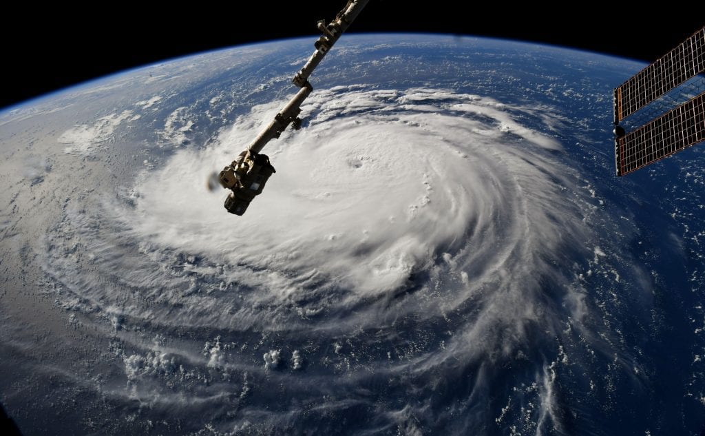


Large swathes of US East Coast is being affected by the devastating Hurricane Florence which has caused massive damage, with storms as high as 9 feet and rainfall as much as 40 inches being recorded by the weather stations. As Hurricane Florence spews surf and rain and causes catastrophic flooding, the best way to minimise the damage caused from the destruction is by preparing beforehand.
In an attempt to minimise the damage caused by Hurricane Florence lashing across US East Coast, NASA and Development Seed are continuously tracking Hurricane Florence using machine learning techniques, which is proving to be highly efficient compared to other traditional methods applied to carry a similar job. This neural network based approach calculates hurricane strength and wind speed by monitoring live imagery delivered from weather satellites.
In the method, data is directly flown from the GOES-16 weather satellite to the NASA Cumulus framework running on AWS, to generate predictions. This is used to create hourly estimates about the hurricane path as opposed to the usual six-hour cycle for similar updates.
Why Are Traditional Methods Incompetent?
Tropical cyclone analysts and forecasters have long been using Dvorak technique as a standard tool for estimating tropical cyclone intensity from satellite imagery. This method uses enhanced infrared to quantitatively estimate the intensity of a tropical system. Based on the cloud patterns in satellite imagery, it shows indication of cyclogenesis before the storm reaches tropical storm intensity. Based on these patterns, a series of rules and careful analysis, a forecast is made. It applies objective rules for relating those patterns to the tropical cyclone intensity.
While the spatial patterns in infrared infrared satellite imagery strongly relate to tropical cyclone intensity, researchers say that parts of Dvorak technique are subjective leading to two different intensity estimates, decreasing the efficiency of the process.
This is where Deep Learning-based Hurricane Intensity Estimator comes into picture which relies on machine learning and deep learning to a great extent.
Machine Learning And Deep Learning Method Deployed By NASA
According to the official website of NASA/MSFC Data Science and Informatics Group explains, Deep Learning-based Hurricane Intensity Estimator is an experimental framework investigating the application of artificial intelligence technologies and cloud computing resources to provide automated and accurate estimation of tropical cyclone intensity. The goal of this investigation is to apply Convolutional neural network (CNN) to satellite data feeds to objectively estimate the tropical cyclone intensity in near real time.
It is well understood that tropical cyclones have a severe impact and the collateral damage caused to life and property from wind speed is severe. If analysts can accurately estimate tropical cyclone intensity, it can prove to be a deciding factor in the amount of loss. Creating a faster and more reliable estimates of storm estimates may therefore lead to better decision making.
In the process, developers are adopting convolutional neural network (CNN) to train a model based on 200,000+ images from the Naval Research Laboratory Tropical Cyclone Archive.
The Hurricane Intensity Estimator is built in association with Mapbox and runs alongside data collected from human estimation and aerial flights. Based on these data, NASA plans to continue to improve the prediction models. The news and weather services can integrate these predictions into the site via API. It is also important to note that all the code and prediction models are open source and would be available to GitHub soon.
How Does It Work?
In the paper titled Tropical Cyclone Intensity Estimation Using a Deep Convolutional Neural Network, researchers from The University of Alabama in Huntsville, used a deep architecture of multiple processing layers composed of linear or nonlinear transformations. As the paper abstract notes, the researchers handcrafted features with automated feature learning and hierarchical feature extraction. They used CNN to model spatial correlation with translation invariance making them suitable for image recognition. This used a deep CNN architecture for estimating the hurricane intensity by learning features.
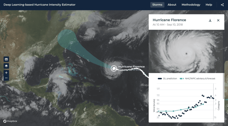
The results of the model are displayed on a web map, where active storm systems are highlighted. Clicking on a storm shows up graphical data that plots the wind speed and category predictions made along the storm path along with NHC storm outlook data. There is also an option to click on the download button to retrieve a CSV file with specific details (such as latitude, longitude, locations) of the storm and wind prediction.
Conclusion
While machine learning has increased the efficiency of tracking natural calamities, human meteorologists are still needed to play crucial role. Machine Learning and deep learning models can play a key role in the tracking the path of life threatening hurricanes and also help forecast damage caused to infrastructure.